
The Shady Bend Trail near Osborne, KS offers about miles of singletrack through a wooded area. The trail is located west of Osborne, just north of the Shady Bend Golf Course. Additional trail mileage, as well as improved trail signage, is in the works.
The Shady Bend Trail was born when two Osborne bikers exploring deer trails started connecting some of them to make loops. Today the Shady Bend Bike Trail twists and winds for 4 miles through a timbered area that hugs the south fork of the Solomon River just west of town. It features terrain gentle enough that novice riders don’t feel overwhelmed but challenging enough when you pick up the pace that more experienced riders will go away smiling when they’re through.
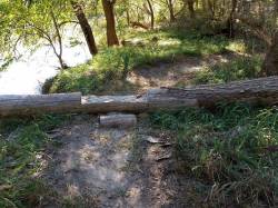
The trail consists of five loops of mostly flat terrain along the South Fork of the Solomon River, although there are some stream banks and shallow sink holes that add variety to the trail. The Shady Bend Trail is easy to find. Follow Osborne’s Main Street west out of town past the Sanders Baseball Complex and the Scout Cabin. Keep going west on the rock road past the turn to the Golf Course clubhouse. This rock road runs along the north bank of the Solomon River and will take you to the shooting range. Just before arriving at the shooting range gate there is a mowed pull out on the left side of the road at the trail heads.
For more information about the trail, contact John McClure at Blue Hills Bikes in Osborne, 785-346-2715.
Web Site: osbornecountyksessentials.blogspot.com
Location: Osborne, KS